


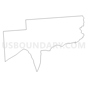
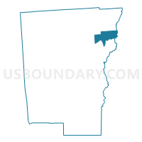
Voting District 100001, Chenango County, New York
About
Outline
Summary
| Unique Area Identifier | 625992 |
| Name | Voting District 100001 |
| County | Chenango County |
| State | New York |
| Area (square miles) | 16.29 |
| Land Area (square miles) | 16.20 |
| Water Area (square miles) | 0.09 |
| % of Land Area | 99.42 |
| % of Water Area | 0.58 |
| Latitude of the Internal Point | 42.62134560 |
| Longtitude of the Internal Point | -75.39211510 |
Maps


Graphs
Select a template below for downloading or customizing gragh for Voting District 100001, Chenango County, New York


Neighbors
Neighoring Voting District (by Name) Neighboring Voting District on the Map
- Voting District 030001, Chenango County, NY
- Voting District 100002, Chenango County, NY
- Voting District 110001, Chenango County, NY
- Voting District 110002, Chenango County, NY
- Voting District 180001, Otsego County, NY
- Voting District 200003, Chenango County, NY
Top 10 Neighboring County Subdivision (by Population) Neighboring County Subdivision on the Map
- Sherburne town, Chenango County, NY (4,048)
- New Berlin town, Chenango County, NY (2,682)
- North Norwich town, Chenango County, NY (1,783)
- Pittsfield town, Otsego County, NY (1,366)
- Columbus town, Chenango County, NY (975)
Top 10 Neighboring Place (by Population) Neighboring Place on the Map
Top 10 Neighboring Unified School District (by Population) Neighboring Unified School District on the Map
- Norwich City School District, NY (13,368)
- Sherburne-Earlville Central School District, NY (8,599)
- Unadilla Valley Central School District, NY (5,602)
Top 10 Neighboring State Legislative District Lower Chamber (by Population) Neighboring State Legislative District Lower Chamber on the Map
- Assembly District 111, NY (132,613)
- Assembly District 107, NY (125,994)
- Assembly District 123, NY (124,261)